Laser Instruments
For sale at Paul. R. Lipp & Son, Inc.
Paul R. Lipp & Son, Inc. offers a vast array of leading-edge construction lasers, software, and surveying equipment for sale. We are a dealer for all major laser instruments and surveying equipment manufacturers.

Laser Instruments Overview
Paul R. Lipp & Son, Inc. established its Construction Lasers and Instruments division in 2000. Most of the devices we refer to are instruments we use in our own operations. We were early adopters and entered the business with more than the usual amount of study and reflection. We will mention some of the products we use and sell.
Sound construction is a function of materials and workmanship; and workmanship is increasingly a function of sophisticated instrumentation. There is probably no more important process in construction than maintaining accurate alignment and elevation control. Without accurate planer, linear and angular measurements the details of construction can not be executed faithfully and structural defects are inevitable.
We Stand Behind Everything We Sell!
Paul R. Lipp & Son is not a passive partner in instrumentation and software sales. We back up everything we sell with training and technical service, walking you and your lead crew through the processes of set-up and operation so that your construction lasers and instruments start saving you money and attaining maximum precision from day one. We're not software engineers, but we give our lead software products a good run-through so we can see the common mistakes people make. However, for real interfacing difficulties we'll refer you to GeoMax, FieldGenius, GeoMax X-Pad, Carlson Software. One of the reasons we decided to represent them is because we can count on solid technical support.
The application of lasers, following “line of sight” to this purpose is natural, and vastly superior to traditional methods which are labor intensive and subject to variations. The earliest application of lasers to civil construction was in pipe laying that relied on gravity flow. Pipe laying involves numerous procedures using excavators and bedding or backfill materials and any physical object used for alignment can be deformed during these operations. However, a laser beam is not susceptible to this and can be aimed to a targeted point to verify the position of the pipe against the engineering drawings.
The construction team can lay a straight line of pipe for a considerable distance using a pipe laser maintaining control of line, grade, and elevation. An optical instrument called an automatic level (auto level) is quite often used by a gravity flow pipe installation crew. An automatic level is like the old builder's level that contained a spirit vial. The difference being an automatic level can level itself within a given range.
Maintaining a consistent plane was the next order of business and this was achieved using a rotating laser beam (such as those manufactured by GeoMax™, AGL™, Futtura®, Laser Reference™/ Pro Shot™, Sokkia™ and Topcon™) mounted on a tripod. This has applications in our sphere in excavating foundations and in setting concrete forms to a consistent height. The beam rotates creating a level beam or, in some cases, a sloped beam of light. In this case it is called a slope laser or grade laser. Any workman within the line of sight can set the target laser detector, mounted on the grade rod, and “tuning” in until a steady beep demonstrates that the target is level with the rotating beam and at the right elevation.
What's HOT!
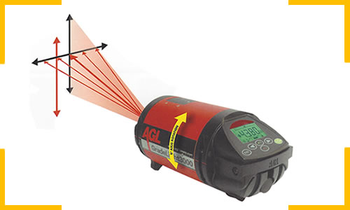
AGL | GradeLight 3000: Features Grade Reference Points, Large Display Viewable from Outside Most Manholes, Line Indicator, Status-at-a-glance, Unique dual Color Grade Display, and more. The rotating beam indicate vertical level exactly in the direction of the laser beam ...
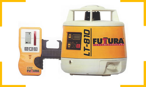
FUTURA | LT-810: An affordable automatic true self-leveling single slope laser. Rugged, reliable, and accurate, the LT810 is designed for any level or sloped application, including concrete forms and footers, grading and excavation, parking garages, ramps, and more ...
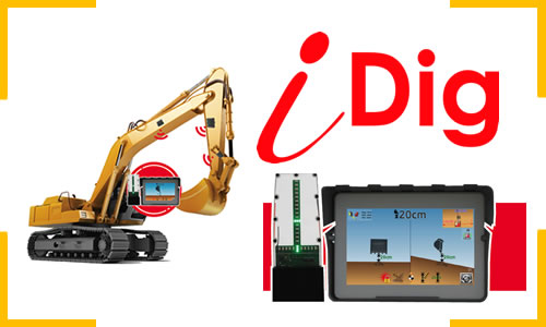
iDig | Control your grade. With the iDig Guidance System, control your excavator without leaving your cab. You will know the position of your bucket to the nearest centimeter without using a grade checker. No Cables. No risk of cables tearing off. The iDig communicates by radio and is charged by solar panels. Installation is simple, no need for a service technician or training to use it. Multi-machines. Buy a single system and install it on several excavators. The iDig is portable from one machine to another in a few minutes. Your iDig never sleeps and you get a return on your investment in a few months!
OUR RECOMMENDATIONS:
Zoom 90
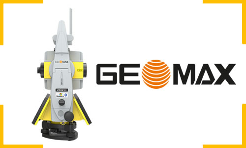
GeoMax | Zoom 90: GeoMax Zoom90 Series fulfills all your needs with one-man fully-operational robotic total stations. Zoom90 is the ultimate one-man system with up to 20% more automation performance, extended reflectorless measurement capability, STReAM360, accXess technologies and Windows CE open connectivity. Because a perfect solution is more than its single components, the Zoom90 seamless integration makes it the ultimate solution.
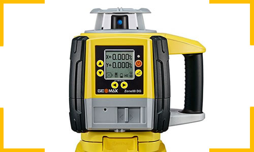
Zone 60DG
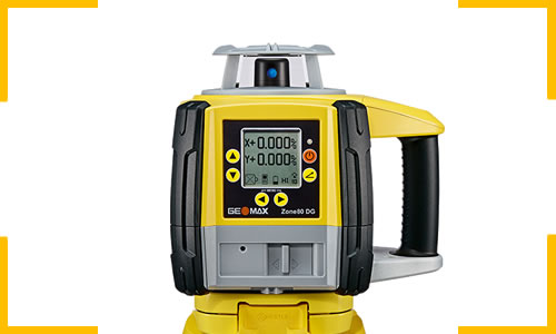
GeoMax | Zone 60DG: Fully-automatic grade specifically designed for construction workers who need the dependability and accuracy of a fully professional grade laser on a daily basis. With a straightforward user interface on both the laser and the RF remote, the craftsman is always in full control.
Futtura CR5
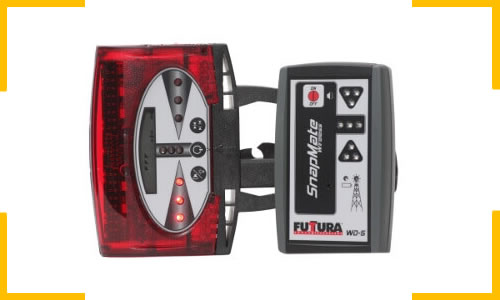
Futtura | CR5: The World's Most Versatile Premium Laser Receiver. The CR5 combination receiver is designed for all rotating lasers and can be hand-held, rod-mounted, or magnetically attached to your machine, making it the most versatile laser receiver in the industry.
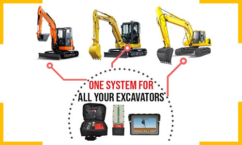
iDig | Touch: One system for all your excavators (Multiple Machines). Do you have several excavators? Perfect, we made a removable solution that attaches in seconds from one machine to another. The iDig can save as many excavator and bucket profiles as you want. In the morning you attach on the sensors, the control box and the LED barograph, then select the right excavator.
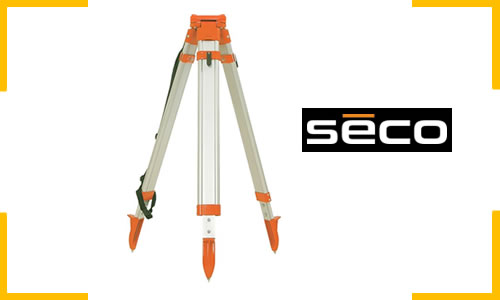
Seco | Aluminum Tripod: Aluminum Tripod with Round Legs Quick Clamp - Orange. These tripods accommodate 5/8 x 11 instruments and are designed for all types of jobs The telescopic Aluminum (Round) legs allow for setup. Extends to 65 in (1.65 m). Features a Quick Clamp lock type with a Triangle/Flat head. Tripod Hardware comes in Orange. Weighs 9.35 lb (4.25 kg)
GeoMax | Zone80: The Zone80 DG is the laser rotator of choice when it comes to land leveling tasks - not only in construction but also agriculture. It is key for long distance applications as well as machine guidance, as it runs on different head speeds, including 20rps (rotation per second). Zone80 DG provides this rotation speed allowing a faultless read out of values by the receiver that is mounted on the machine. The best thing – the laser rotator offers all those features at an affordable cost.
Total Stations are nothing more than Transits with EDM (Electronic Distance Measurement). These extend the earlier systems even further, providing a full capacity to determine distance and horizontal angle and vertical angle; thereby establishing a point with three dimensions (easting, northing and height; or x y z coordinates). The instrument is leveled and optically plumbed over a pin or a stake and a beam of light is shot into a prism mounted to a prism rod, held by the rod-man to determine a position. Some total stations are “reflectorless” meaning that they are able to measure without a prism and also without the corresponding rodman. This is checked against manually entered or downloaded coordinates and by progressive steps the rod-man locates the stake and target at the points defined by the civil engineers or surveyors. Further automation is now possible with fully robotic total stations, which can be operated by the rod-man alone, eliminating the need for an instrument man. In fact the robotic systems now in use can be programmed via *Bluetooth® wireless or via a flash drive through the on-board USB port.
Machine Control Receivers are installed on every one of our excavators
Machine Control Receivers are installed on every one of our excavators, augmenting the Excavator Grade Indicate Systems, such as the iDig system. These are also an integral element of the Machine Control Systems (MCS) we represent from AGL™, and Inteq™. These machine control systems, as used on dozers, graders, and boxblades, “dial in” the blade depth based on the dead reckoning laser signal from the rotating laser transmitter. With the operator focused on the display directing his course and first setting the blade to the correct vertical elevation, the on board computer elevates and lowers the blade. This excavator depth control and excavator grade control system minimizes the number of passes the equipment has to make and eliminates errors requiring remediating fill and grading.
What’s next?
Precision GPS (Global Positioning Satellite) and RTK (Real Time Kinetic) technologies, provide absolute positioning of longitude, latitude and elevation automatically and provide digital readouts for verification against engineering drawings. Fog and rain are still the bane of the precision work crew’s existence. There is still a limit as to what you can do in rain, but GPS and RTK give you a good chance to keep your crews on the job and making progress in fog and drizzle – the things that deflect light and slacken guide lines. When building season begins excavators need cash flow and they need it now. These advanced technologies go a long way towards jump starting cash flow and keeping it moving.
Software
Paul R. Lipp & Son, Inc. is a reseller of many leading Software Products, assisting every aspect of project management and technical implementation. We are presently keying in on the products of greatest interest to our fieldwork customers, the surveyors, estimators, and work crews. Call us at 888-396-5477 for more information.
GPS surveying and layout staking allows work to proceed more efficiently by eliminating one person from the traditional survey crew of an instrument man and a rodman. The main limitation of standard GPS is that the instrument has to be at rest to attain the precise calibration required for survey and layout work. This means repeated stopping to verify real position against the theoretical position anticipated from the previous known precise position. It remains an excellent system, but it has been improved upon. RTK, on the other hand, acquires data on a real time basis and re-calibrates in an instant for continuous uninterrupted operation, making it suitable for excavating machine control. By these improvements excavation is rapidly approaching the speeds and flexibility of CNC machining and operating at an equal precision relative to scale.